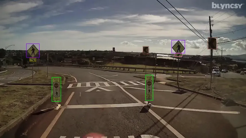
US road asset map

Blyncsy sets out US road asset map.
By MJ Woof November 7, 2024 Read time: 1 min
The new mapping tool from Blyncsy allows open access views of asset data for the entire US


Blyncsy, part of Bentley Systems, has published a public map of the interstate highways in the United States. This shows key roadway assets and can be used to support roadway safety and maintenance works. This data is available to all state US Department of Transportation (DOT) agencies. Using the information means that states to better address road safety, maintenance, and repair operations more efficiently and cost-effectively.

The new Blyncsy interstate highway map uses crowdsourced dash camera imagery from over 1 million vehicles. Coupled with Blyncsy’s powerful AI image analysis toolset, the system is able to detect over 40 different road conditions and asset inventory issues in near-real time. Typical issues include potential roadway safety hazards from damaged guardrail, missing signage, and lack of proper road striping. The system can highlight roadway vulnerabilities to crashes, natural disasters, and work zone areas. 

Blyncsy’s AI-powered crowdsourced data is delivered through an open API, providing state DOTs a solution that is infinitely scalable and cost-efficient when compared to manual data collection technologies like LiDAR, or traditional road inspection, which require maintenance crews in the field to collate data.


 

For more information on companies in this article

Related Content

  • Drivewyze: US e-inspections on the rise
    May 31, 2022
    Momentum is growing for electronic inspections at weigh stations, according to Drivewyze, operator of the largest public-private weigh station bypass network in North America.
  • Data sharing boosts workzone safety
    March 19, 2012
    Faster and safer utilities works are the benefit of innovative data sharing moves – Mike Woof writes. Utilities works in urban areas can cause major problems with regard to traffic congestion, as well as posing key safety issues for road users and site workers. Better planning of utilities operations can help tackle congestion and prevent jams, while also ensuring that on-site personnel have a safer working environment. To ensure that site workers know the exact location of buried utilities, comprehensive m
  • Workzone safety protects workforce and drivers
    May 3, 2012
    Highway construction work zones are dangerous places, and anything that can improve safety is welcomed as Patrick Smith reports. The safe and efficient flow of traffic through work zones is a major concern to transportation officials, industry, the public, businesses, and commercial motor carriers. This is the view of the US Federal Highway Administration (FHWA), which has developed the Highway Work Zone Safety Program to reduce the fatalities and injurious crashes in work zones, and to enhance traffic oper
  • World Road Meeting 2017
    April 16, 2018
    The IRF World Road Meeting 2017 was held recently – World Highways’ India correspondent Partha Pratim Basistha reports The 18th World Road Meeting of the International Road Federation took place between 14-17 November 2017 in the North Indian state of Uttar Pradesh at Greater Noida near India’s capital New Delhi. Close to 1500 delegates and visitors across the world - including India - from the road infrastructure fraternity participated at the global event. The Cross Roads meeting, coinciding with an ex