
US road asset map

Blyncsy sets out US road asset map.
By MJ Woof November 7, 2024 Read time: 1 min
The new mapping tool from Blyncsy allows open access views of asset data for the entire US


Blyncsy, part of Bentley Systems, has published a public map of the interstate highways in the United States. This shows key roadway assets and can be used to support roadway safety and maintenance works. This data is available to all state US Department of Transportation (DOT) agencies. Using the information means that states to better address road safety, maintenance, and repair operations more efficiently and cost-effectively.

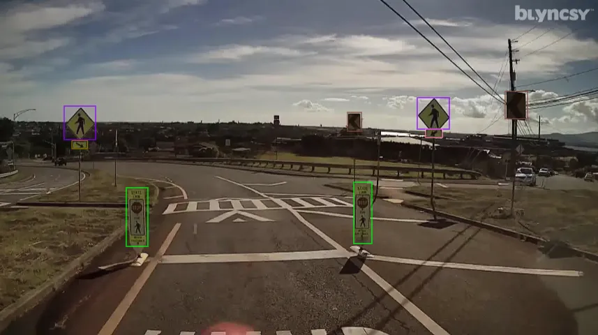
The new Blyncsy interstate highway map uses crowdsourced dash camera imagery from over 1 million vehicles. Coupled with Blyncsy’s powerful AI image analysis toolset, the system is able to detect over 40 different road conditions and asset inventory issues in near-real time. Typical issues include potential roadway safety hazards from damaged guardrail, missing signage, and lack of proper road striping. The system can highlight roadway vulnerabilities to crashes, natural disasters, and work zone areas. 

Blyncsy’s AI-powered crowdsourced data is delivered through an open API, providing state DOTs a solution that is infinitely scalable and cost-efficient when compared to manual data collection technologies like LiDAR, or traditional road inspection, which require maintenance crews in the field to collate data.


For more information on companies in this article

Related Content

  • Infrastructure intelligence plays key role in construction
    October 13, 2023
    Infrastructure intelligence is playing a key role in construction.
  • US bridges needing repair or replacement
    September 13, 2024
    Nearly 221,800 US bridges are needing repair or replacement.
  • IBI’s Routemapper charts new territory with Highways England
    September 14, 2016
    Mapping the asset High-speed data collection just got faster for England’s newly created strategic roads operator Highways England’s establishment as a publicly held company in 2015 created a need for a highly accurate asset inventory. This was potentially very costly and had serious safety implications. As well as its relationships with numerous managing agents and contractors, assets include 35,300km of highway, 12,100km of earthworks, 23,200km of safety fences, 150,000 technology assets and sig
  • Positioning tools continue to improve
    July 16, 2012
    Topcon says that its new IP-S2 package combines GNNS positioning capabilities with inertial sensors, while the firm also has a solution for customers wanting to mix and match receiver components. The IP-S2 is a vehicle-mounted, mobile 3D tool that offers precision mapping and surveying capabilities. The package collects data using 3D laser scanners, LIDAR, and/or cameras, and this is then integrated, time-stamped and geo-referenced. The customer can use this assembled data to combine LIDAR point cloud and d