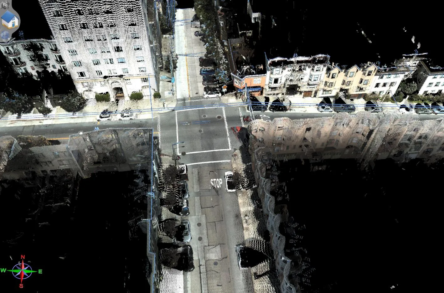
Topcon Europe Positioning says that its new IP-S2 Compact+ package is an innovative mobile mapping system that can accurately measure objects even in adverse weather conditions and enclosed job sites such as tunnels and mines. This replaces the earlier Topcon’s IP-S2 system, launched in 2009. The new vehicle-mounted system has improved scanner orientation to optimise visibility of roadside assets and is packaged in an affordable, compact system that fits on a car or truck. It offers full-colour, high-resolu
February 8, 2013
Read time: 2 mins
Topcon’s new mapping system offers high functionality
5962 Topcon Europe Positioning says that its new IP-S2 Compact+ package is an innovative mobile mapping system that can accurately measure objects even in adverse weather conditions and enclosed job sites such as tunnels and mines. This replaces the earlier Topcon’s IP-S2 system, launched in 2009. The new vehicle-mounted system has improved scanner orientation to optimise visibility of roadside assets and is packaged in an affordable, compact system that fits on a car or truck. It offers full-colour, high-resolution, high-density point clouds and these can increase efficiencies in GIS asset management such as utilities, and transportation work such as roads, highways, tunnels, and overpasses. The Compact+ system is available in two configurations: a three-scanner standard model or a five-scanner system. The three-scanner gives a 360° vertical field of view. The five-scanner system increases cloud density, minimises scanning shades, and collects 150,000 points per second with a range of 40-50m. The IP-S2 Compact+ can be purchased with a high accuracy commercial grade or a tactical grade IMU. The commercial grade IMU is a non-ITAR restricted device without export control. According to Topcon, the Compact+ system is easy to use and can be used in a variety of applications, while it provides high accuracy data and dynamic imaging for any mapping project.
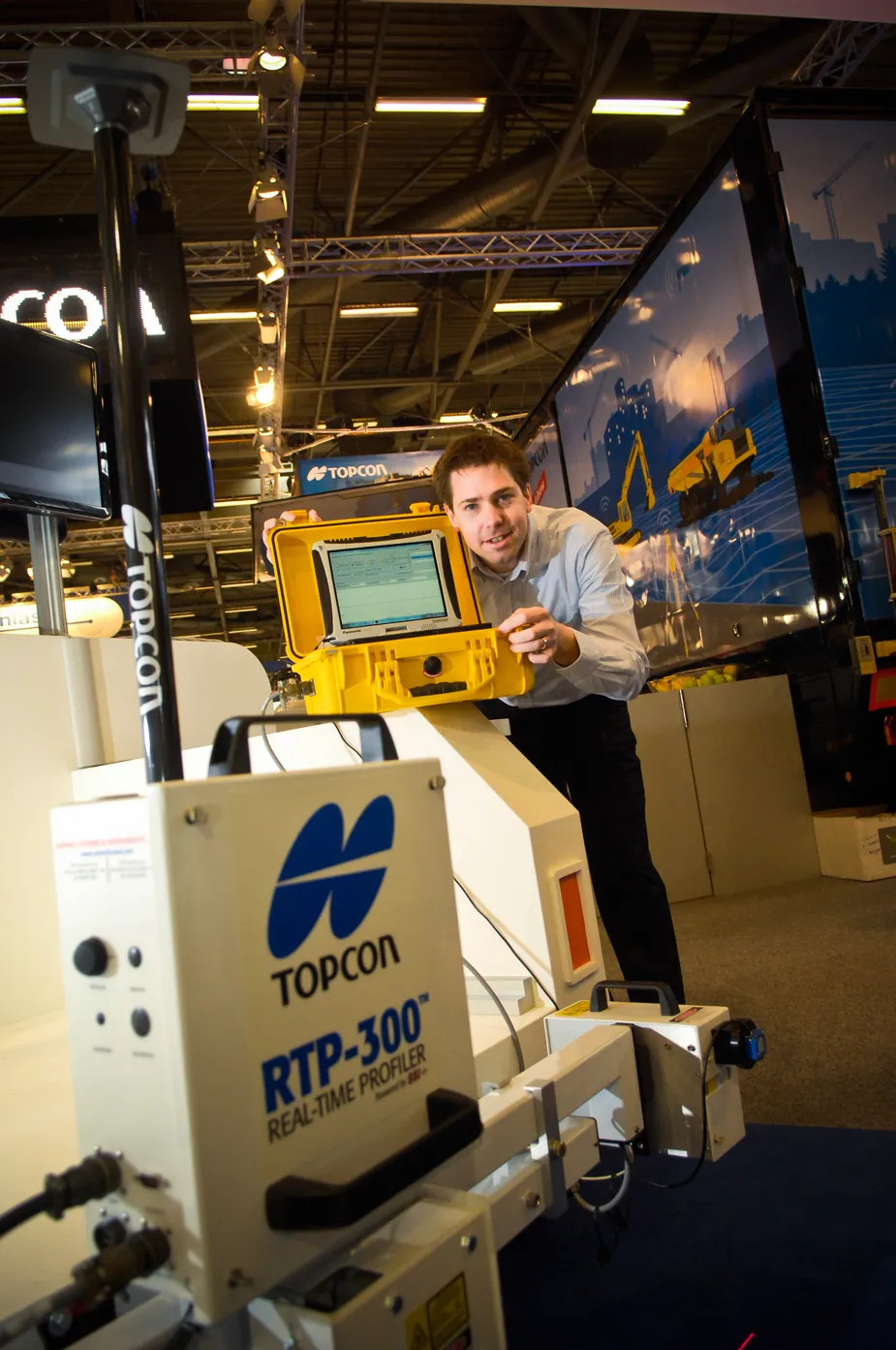
Topcon’s RTP-300 machine, launched at INTERMAT, is no slouch in providing fast and exact road surface data for construction companies and highway authority consultants. “What is typically used is a car [fitted with road surface profiling technology] that needs to keep stopping when scanning a road surface profile. On larger highways, this has meant the road needs to be closed,” said Achiel Sturm, Topcon’s marketing manager.
Topcon Positioning Group and DynaRoad Oy of Helsinki, Finland, have announced the release of DynaRoad 5.3 construction planning and control software. Juuso Makinen, CEO of DynaRoad Oy, said, “One of the largest project management challenges is collecting real-time information from large sites and comparing it to plans. We’re excited to be the first ones offering a solution to this.” DynaRoad claims to be the first software in the world to automatically monitor, update, and report schedule progress of eart