The news that a key highway bridge has collapsed in the US comes as gloomy reading for all in the highway sector. When a section of the Interstate 5 Bridge over the Skagit River in Washington failed in May 2013, a number of vehicles were plunged into the river. Luckily no-one was killed in the incident on the route, which is one of the main links between the US and Canada, and the parallel bridge was able to carry traffic, albeit with delays for users.
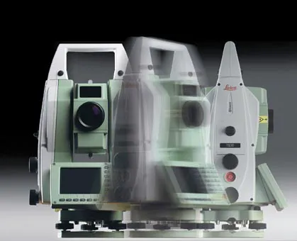
Leica Geosystems says that its TS30 package is a new high precision Total Station that meets highest standards in all surveying applications. Distances can now be measured with Leica Geosystems' proven PinPoint EDM Technology with an unprecedented precision of 0.6mm + 1ppm on prisms. On natural surfaces a high accuracy of 2mm + 2ppm up to 1,000m can be achieved.
Development of the connected and sustainable highways is moving quickly in the US and the Far East but progress in Europe is much less impressive. One example of a connected highway that offers an interesting model for European transport planners and policymakers is The Ray, a 29km stretch of Interstate 85 in the state of Georgia.
Originally established by a charitable foundation, The Ray offers an inspiring vision of a sustainable highway, even for the near future. Drivers crossing the state line from Ala
Dutch surveying company Geomaat says it is taking millimetre accurate measurements in record time to aid a range of highway design, construction and maintenance projects. Using the mobile laser mapping system StreetMapper, and specially developed point cloud software, Geomaat says it can calculate highly accurate cutting, milling and asphalt figures, create as built models and undertake change detection.