Smart traffic analysis improvements

Transport and traffic analysis nowadays tends to switch between static analysis modelling for large scale studies and microsimulation for finer grain work, with perhaps the mesoscopic model also finding a place for mid-level. Most producers make software tools at all three levels and increasingly package them together. Spanish firm TSS (Transport Simulation Systems) has gone one better with its latest release Aimsum 7, by giving it the capacity to "zoom in" from a larger scale mesoscopic model to a smaller
June 12, 2012 Read time: 2 mins
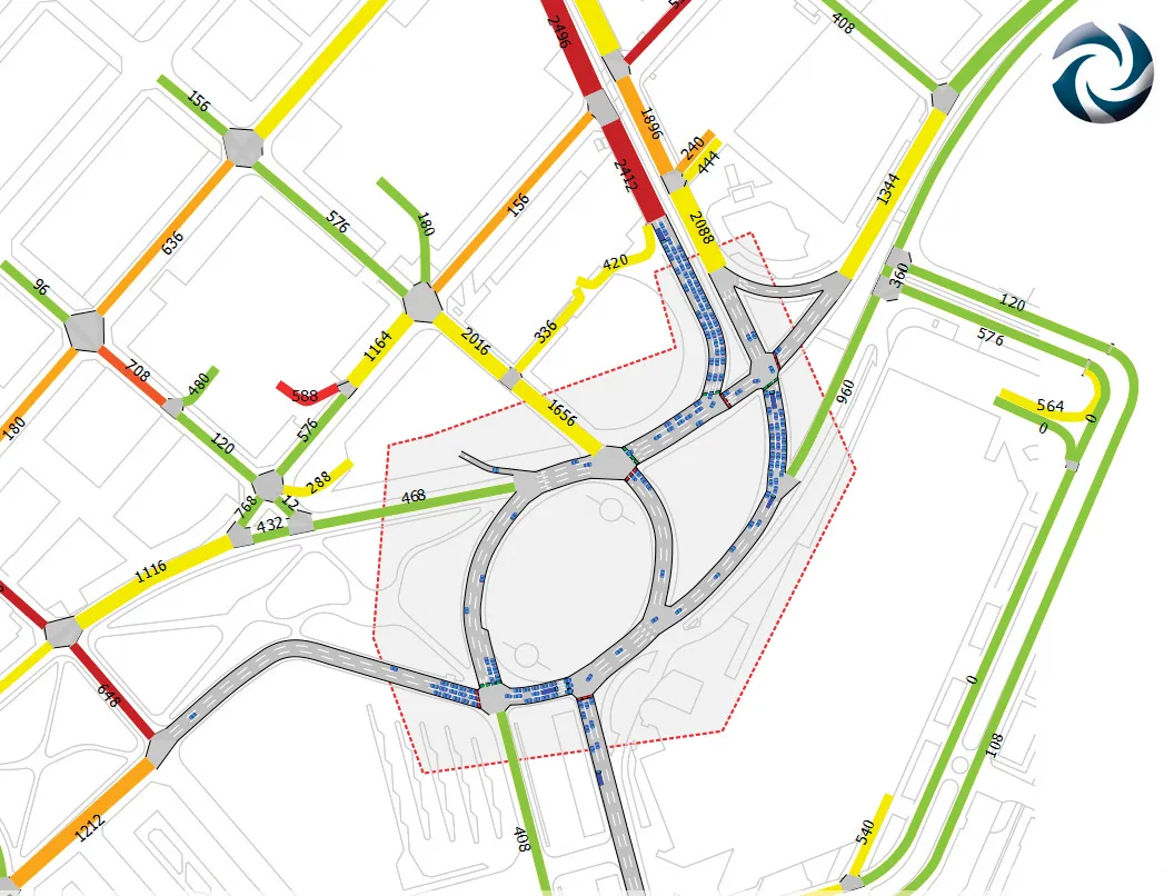
A mesoscopic model of the Aimsun hybrid simulator showing a microscopic pocket of greater detail

Transport and traffic analysis nowadays tends to switch between static analysis modelling for large scale studies and microsimulation for finer grain work, with perhaps the mesoscopic model also finding a place for mid-level. Most producers make software tools at all three levels and increasingly package them together.

Spanish firm TSS (Transport Simulation Systems) has gone one better with its latest release Aimsum 7, by giving it the capacity to "zoom in" from a larger scale mesoscopic model to a smaller area that need microsimulation work, all on the one screen.

It calls the concept the "hybrid simulator" which combines an event-based mesoscopic model with a more detailed time-sliced microsimulation.

This marks a sea change in how traffic models will be conceived, the firm claims, declaring that the method means models will not simply be built once and then discarded. "The hybrid makes it possible for the first time to build demand models on a larger and larger scale using a single all-in-one package,” claimed TSS managing director Jaime Ferrer “with no cumbersome manual interfacing between macroscopic and microscopic models and no need to be updating and revising separate models with independent networks and databases."

154 Aimsun 7 also includes a new network revisions feature, which allows a change made in the base network model to apply automatically to all related future scenarios.

Another new feature is the FZP exporter, which exports simulations to 685 Autodesk 3Ds Max for high–quality 3D presentations. OpenStreetsMap importer allows import of geometry from anywhere via the internet.

For more information on companies in this article

Related Content

  • Highway developments to boost east-west transport
    April 4, 2012
    Huge highway developments are being planned and carried out to further improve East-West transport, with Central Asia a key region as Patrick Smith reports History was made in late 2010, when one of the biggest road building projects ever envisaged in Eastern Europe was given the green-light. It was the occasion when Russian president Dmitry Medvedev signed a law that would allow his country to build its segment of a huge highway around the Black Sea. The idea is to complete the 7,140km highway, wi
  • Beijing to test traffic dispersion by dynamic route guidance
    July 2, 2012
    Nissan Motor Company and the Beijing Municipal Commission of Transport will begin an eight-month large-scale demonstration test in the city's Wangjing district to verify the effects of traffic dispersion by dynamic route guidance with IT devices.
  • Beijing to test traffic dispersion by dynamic route guidance
    March 1, 2012
    Nissan Motor Company and the Beijing Municipal Commission of Transport will begin an eight-month large-scale demonstration test in the city's Wangjing district to verify the effects of traffic dispersion by dynamic route guidance with IT devices.
  • Advanced machine control solutions
    February 15, 2012
    Trimble has developed an array of smart solutions for GPS machine control applications, which can now be installed on a wide variety of machines from different manufacturers. The company has long had a close relationship with Caterpillar but can also install units on machines from a range of manufacturers including Case, John Deere, Komatsu, Liebherr, Roadtec and Volvo. The firm's range has developed beyond just the GPS hardware though and includes sophisticated software, which can be loaded onto a hand-hel