Measuring night and day visibility of road markings

Box International studies have proven that relatively more accidents and fatalities happen during night-time driving compared to day-time driving. At the end of 2008, Danish company DELTA launched its latest model, the LTL-XL, a fourth generation portable retrometer for measuring night and day-time visibility of all types of road markings. "Measures are traceable to PTB (Physikalisch-Technische Bundesanstalt), Germany and NIST (National Institute of Standards), USA. LTL-XL measures according to the internat
April 12, 2012 Read time: 2 mins
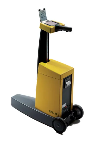
The LTL-XL from DELTA: built in modules

Box International studies have proven that relatively more accidents and fatalities happen during night-time driving compared to day-time driving.

At the end of 2008, Danish company 199 Delta launched its latest model, the LTL-XL, a fourth generation portable retrometer for measuring night and day-time visibility of all types of road markings.

"Measures are traceable to PTB (3998 Physikalisch-Technische Bundesanstalt), Germany and NIST (National Institute of Standards and Technology), USA. LTL-XL measures according to the international standards EN1436 and ASTM E-1710," says DELTA.

Its LTL-XL offers several new features compared to previous instruments from DELTA and these include the measuring of the ambient temperature and humidity; geotagging using GPS mapping software; USB connectivity and seamless connection to any system using a Web browser.
LTL-XL full instrument
The LTL-XL from DELTA: built in modules
The new equipment is offered with a new coloured display, single-handed operation and single touch controls, which makes the operator's work much easier.

Using LED technology, which makes the instrument almost maintenance free, LTL-XL allows users to work efficiently with measuring times of 1-3 seconds and a large memory of more than 200,000 measurements.

"LTL-XL is built in modules to allow the operator to design the instrument according to actual needs. It comes in a base model to which can be added wheels and telescopic handle, GPS and printer," says DELTA.

For more information on companies in this article

Related Content

  • Caterpillar’s versatile backhoe loader
    December 7, 2017
    Caterpillar is now offering a highly versatile backhoe loader model aimed specifically at the African and Middle Eastern markets The Cat 426F2 model is said to able to carry out a wide range of duties and is offered in two and four-wheel-drive variants. Customers can also choose between backhoe loader or excavator control patterns and choose from other options including cab climate control packages and the firm’s Product Link technology.
  • Slurry sealing options with sophisticated new machines
    June 19, 2017
    New technologies and more efficient have also been developed for slurry sealing applications. Bergkamp is introducing the M310CS truck-mounted slurry seal and micro surfacing paver, with power coming from its Tier 4 emissions compliant truck engine. With PTO-driven hydraulic pumps, the M310CS has eliminated the need for a side engine. This reduces exhaust emissions, noise and vibration. The M310CS is features the sophisticated electronic mix control and diagnostic (EMCAD) system, which is designed to manage
  • Asphalt plant technology meets market needs
    February 16, 2012
    Plants for mixing asphalt are becoming more sophisticated than ever, while users are looking for ecological and technological benefits. Patrick Smith reports. When the Adige Bitumi Group decided to renew its old M 260 plant it chose to collaborate with Marini for the design and development of a plant with production of 280-300tonnes/hour.
  • Positioning tools continue to improve
    July 16, 2012
    Topcon says that its new IP-S2 package combines GNNS positioning capabilities with inertial sensors, while the firm also has a solution for customers wanting to mix and match receiver components. The IP-S2 is a vehicle-mounted, mobile 3D tool that offers precision mapping and surveying capabilities. The package collects data using 3D laser scanners, LIDAR, and/or cameras, and this is then integrated, time-stamped and geo-referenced. The customer can use this assembled data to combine LIDAR point cloud and d