Measuring night and day visibility of road markings

Box International studies have proven that relatively more accidents and fatalities happen during night-time driving compared to day-time driving. At the end of 2008, Danish company DELTA launched its latest model, the LTL-XL, a fourth generation portable retrometer for measuring night and day-time visibility of all types of road markings. "Measures are traceable to PTB (Physikalisch-Technische Bundesanstalt), Germany and NIST (National Institute of Standards), USA. LTL-XL measures according to the internat
March 16, 2012 Read time: 2 mins
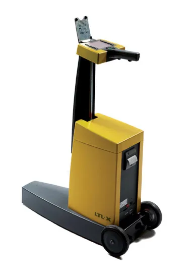
The LTL-XL from DELTA: built in modules

Box International studies have proven that relatively more accidents and fatalities happen during night-time driving compared to day-time driving.

At the end of 2008, Danish company 199 Delta launched its latest model, the LTL-XL, a fourth generation portable retrometer for measuring night and day-time visibility of all types of road markings.

"Measures are traceable to PTB (3998 Physikalisch-Technische Bundesanstalt), Germany and NIST (National Institute of Standards), USA. LTL-XL measures according to the international standards EN1436 and ASTM E-1710," says DELTA.

Its LTL-XL offers several new features compared to previous instruments from DELTA and these include the measuring of the ambient temperature and humidity; geotagging using GPS mapping software; USB connectivity and seamless connection to any system using a Web browser.The new equipment is offered with a new coloured display, single-handed operation and single touch controls, which makes the operator's work much easier.

Using LED technology, which makes the instrument almost maintenance free, LTL-XL allows users to work efficiently with measuring times of 1-3 seconds and a large memory of more than 200,000 measurements.

"LTL-XL is built in modules to allow the operator to design the instrument according to actual needs. It comes in a base model to which can be added wheels and telescopic handle, GPS and printer," says DELTA.

For more information on companies in this article

Related Content

  • Precision measurements
    February 7, 2012
    Nikon-Trimble is now offering the new Nikon 25mm and 127mm Total Stations, which are said to deliver improved accuracy over previous products.
  • Precision narrows the gap between design software and GIS
    March 20, 2012
    Greater precision is helping blur the boundaries between GIS technology and design software While GIS map based technology has extended its range across an ever more universal spectrum of uses in the highways sector, it is increasingly showing weaknesses for engineering purposes. It is very often not accurate enough. This has not mattered previously because the GIS tool has been seen essentially as an automated version of paper based systems from the design department's point of view. Where engineers
  • Sophisticated software solutions offering surveying innovation and construction efficiency
    August 28, 2014
    An array of new software tools will deliver greater efficiencies to construction companies – Mike Woof writes. Sophisticated software systems are delivering advanced solutions to traditional construction tasks. Key developments have been made by major players in the sector, such as Bentley Systems, Fugro Roadware, Leica Geosystems and Topcon Sokkia. From Bentley comes a new package that will help road construction activities in urban areas featuring a heavy concentration of underground utilities. This n
  • Topcon offers the potential for smoother roads
    May 11, 2018
    An improved package from Topcon Positioning will allow upgrades in road surface quality. The firm is launching an upgrade to its SmoothRide data collection software. This new RD-M1 Collect 2.0 package includes updates that make the mapping of road conditions easier and more efficient. The improved interface is designed to simplify setup and automatically detect the position of the wheel sensor during data collection.