'Five innovations in one'

The new ZRM 6014 road marking retroreflectometer from Zehntner is said to incorporate five innovations in one go: telescope handle and wheels as standard, colour touch display, camera, level meter and compass.
February 9, 2012 Read time: 2 mins
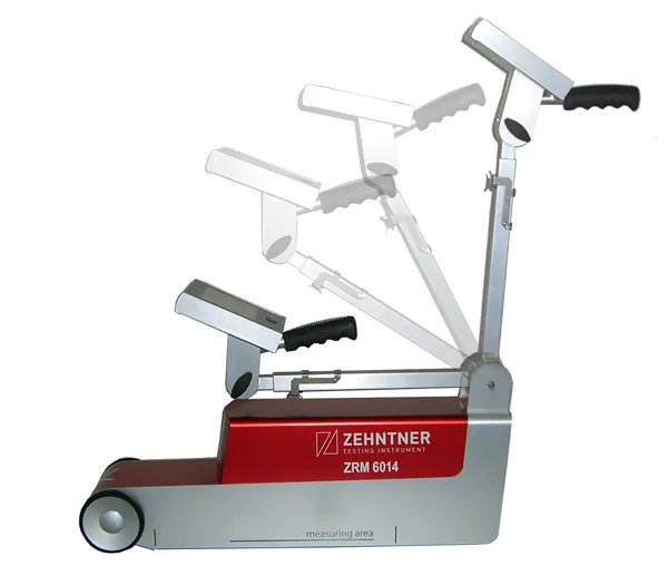
Zehntner's new ZRM 6014 road marking retroreflectometer "incorporates five innovations in one go"

The new ZRM 6014 road marking retroreflectometer from Zehntner is said to incorporate five innovations in one go: telescope handle and wheels as standard, colour touch display, camera, level meter and compass.

"The main focus has been put on speeding up the measuring process of road markings. RL and Qd are measured in about two seconds: single measurements of RL or Qd take only one second each," says managing director Peter 1285 Zehntner.

"Somebody who has actually been on the road for measurements knows that speed is of the essence." As well as the RL and Qd values temperature and air humidity are recorded simultaneously. Extensive options to configure the instrument include a level meter to determine the gradient of the road; a compass that indicates the orientation and a GPS receiver allows precise positioning of the results. As standard, all this information can be displayed on mapping software for easy evaluation.

An optional built-in camera allows the user to get a picture of the marking from the point of view of the measuring instrument, which is said to be helpful when in doubt during the evaluation of critical results.

Data can be transferred to a PC or memory stick within seconds, and a built-in printer can print measuring results on the spot.

For more information on companies in this article

Related Content

  • Software alliance improves productivity
    June 12, 2012
    In the fast moving world of construction software, major innovations are happening on a continuous basis. All the leading players are making notable contributions to the sector. A new strategic alliance just announced between the management and data handling software giant Pitney Bowes, and design and construction software producer Autodesk, will help create an end to end range of products and tools for rapidly evolving BIM strategies in the industry. In particular in should help develop an integrated suite
  • Highway design software developments
    February 21, 2012
    New advanced software is being released for use by those involved in highway design as Adrian Greeman reports. The growing importance of BIM, building or project information modelling, as a design and construction process, and not just 3D modelling, is the driving force for the latest 2012 versions of Autodesk's comprehensive range of software for civil engineers. This is reflected in a new packaging of its various software tools into suites (along the lines of Microsoft's office suites) tailored to variou
  • Leica Geosystems launches iCON for wheeled loaders
    January 6, 2017
    Leica Geosystems has unveiled its new powerful Leica iCON 3D machine control system for wheeled loaders. The Swiss firm says the system allows users to complete their earthworks jobs faster and correctly the first time. It is also said to precisely control material cut and fill, saving a lot of time and money by reducing rework and over-excavation, while also making grading operations with wheeled loaders more efficient. Grade checking, says Leica, can be eliminated, further enhancing productivity, efficien
  • Leica Geosystems launches iCON for wheeled loaders
    April 19, 2013
    Leica Geosystems has unveiled its new powerful Leica iCON 3D machine control system for wheeled loaders. The Swiss firm says the system allows users to complete their earthworks jobs faster and correctly the first time. It is also said to precisely control material cut and fill, saving a lot of time and money by reducing rework and over-excavation, while also making grading operations with wheeled loaders more efficient. Grade checking, says Leica, can be eliminated, further enhancing productivity, efficien