'Five innovations in one'

The new ZRM 6014 road marking retroreflectometer from Zehntner is said to incorporate five innovations in one go: telescope handle and wheels as standard, colour touch display, camera, level meter and compass.
February 9, 2012 Read time: 2 mins
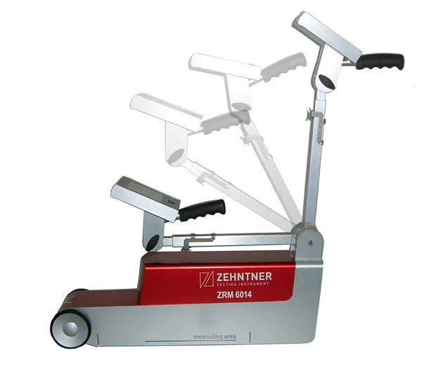
Zehntner's new ZRM 6014 road marking retroreflectometer "incorporates five innovations in one go"

The new ZRM 6014 road marking retroreflectometer from Zehntner is said to incorporate five innovations in one go: telescope handle and wheels as standard, colour touch display, camera, level meter and compass.

"The main focus has been put on speeding up the measuring process of road markings. RL and Qd are measured in about two seconds: single measurements of RL or Qd take only one second each," says managing director Peter 1285 Zehntner.

"Somebody who has actually been on the road for measurements knows that speed is of the essence." As well as the RL and Qd values temperature and air humidity are recorded simultaneously. Extensive options to configure the instrument include a level meter to determine the gradient of the road; a compass that indicates the orientation and a GPS receiver allows precise positioning of the results. As standard, all this information can be displayed on mapping software for easy evaluation.

An optional built-in camera allows the user to get a picture of the marking from the point of view of the measuring instrument, which is said to be helpful when in doubt during the evaluation of critical results.

Data can be transferred to a PC or memory stick within seconds, and a built-in printer can print measuring results on the spot.

For more information on companies in this article

Related Content

  • Connected Tech for Construction Continuity
    December 11, 2020
    No one could have predicted the situation we found ourselves in in 2020, with a global pandemic bringing the economy to its knees, projects delayed overnight, rapid restarts, remote management, and challenging labor dynamics.
  • Topcon announces increased integration with Autodesk scanning software
    June 2, 2016
    Topcon Positioning Group has announced increased integration in the Autodesk and Topcon reality data workflow that it says is designed to increase project efficiency. Raw scan data from the Topcon GLS-2000 laser scanner can now be taken directly into Autodesk ReCap 360 and ReCap 360 Pro with no intermediate software conversion steps necessary. Topcon said that this integration is designed to streamline point cloud analysis to quickly identify conflicts, measure variations and make adjustments at vari
  • Scania uses Navteq data for Active Prediction system
    March 1, 2012
    Navteq has been selected by Scania to provide map data featuring the accurate, reliable and detailed road attributes essential to its innovative new active prediction system.
  • Developments in workzone safety systems
    May 3, 2012
    Raising awareness of safety in highway work zones is a global issue, and various initiatives highlight this as Patrick Smith reports. So seriously is work zone safety taken in the United States that each year since 1999 a special week has been set aside to highlight it. Each year in April, National Work Zone Awareness Week is held to bring national attention to motorist and worker safety and mobility issues in work zones.