GSSI offers bridge monitoring tool

GSSI is introducing the sophistictaed BridgeScan condition assessment system. This package is used for concrete inspection and utility mapping of bridges. Said to be both affordable and versatile, this ground penetrating radar (GPR) equipment can be used to assess concrete condition on bridge decks, as well as parking structures. Using this unit offers accurate assessments of concrete condition, which improves repair cost estimation and saves time and money. With BridgeScan, identification of rebar
May 19, 2015 Read time: 2 mins
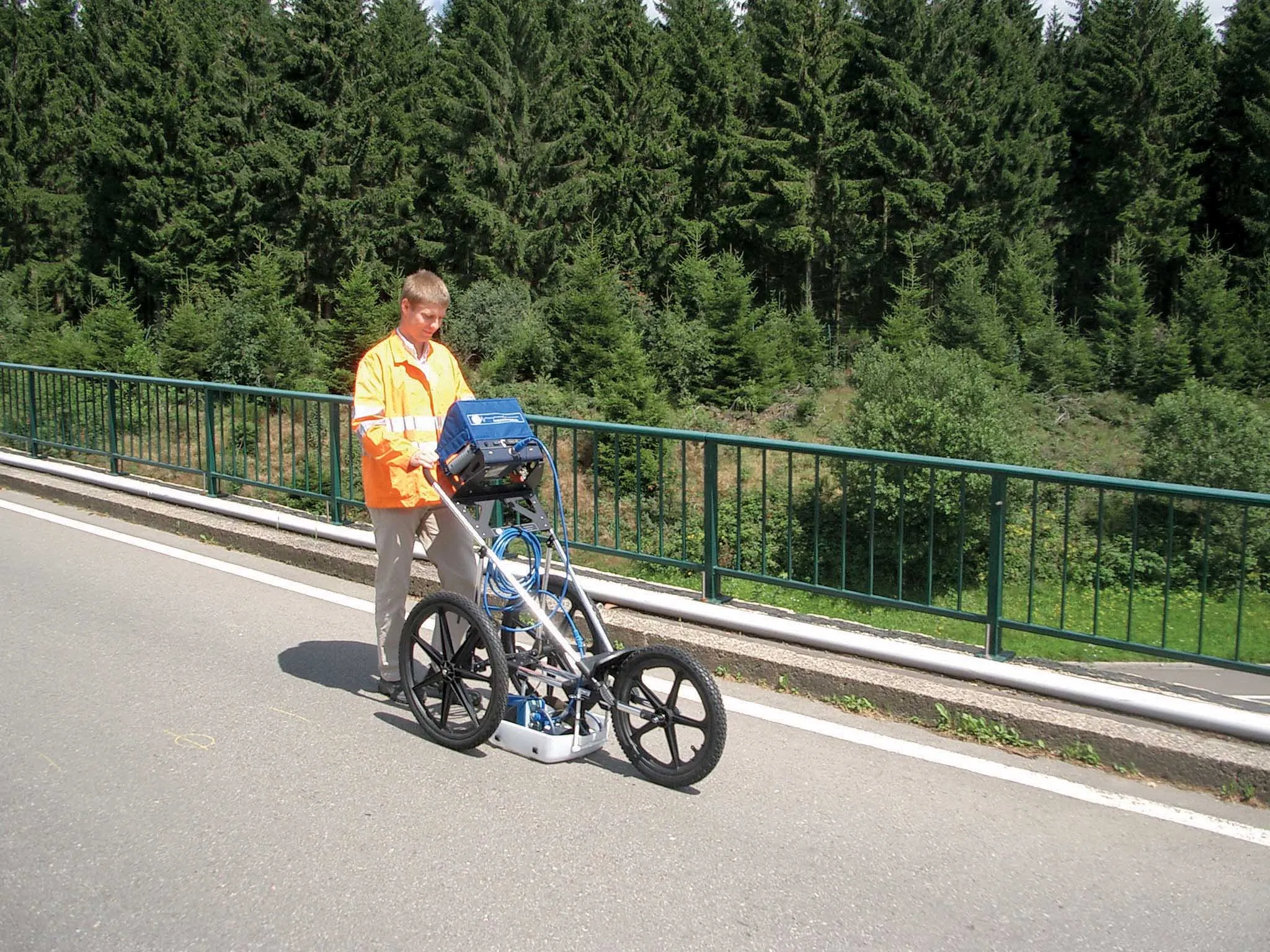
The BridgeScan monitoring system from GSSI comes with its own cart for versatility of use
8095 GSSI is introducing the sophistictaed BridgeScan condition assessment system. This package is used for concrete inspection and utility mapping of bridges.

Said to be both affordable and versatile, this ground penetrating radar (GPR) equipment can be used to assess concrete condition on bridge decks, as well as parking structures. Using this unit offers accurate assessments of concrete condition, which improves repair cost estimation and saves time and money.

With BridgeScan, identification of rebar location and depth is said to be easy and quick. It can handle bridge deck condition assessments, determining concrete cover depth on new structures, and concrete inspection, as well as measuring slab thickness, and void detection and location. Construction professionals, utility locators, and engineers can also use the unit as a basis for a utility locating GPR system to map and locate underground infrastructure – pinpointing the depth and position of metallic and non-metallic pipes in real time.

Unlike other units, the firm says that the BridgeScan system is aimed at bridge condition assessment. It can accurately represent bridge data by automatically accommodating for bridge skew angle. Using a non-destructive method of evaluating bridge deck thickness, the BridgeScan system is said to obtain reliable thickness measurements in minutes, eliminating the need to core.

The BridgeScan system includes the SIR 3000 control unit, a small, lightweight GPR system designed for single-user operation, which incorporates advanced signal processing and display capability for in-the-field 3D imaging. The same control unit can be used for multiple applications. Other BridgeScan components include a 1600MHz antenna, a three-wheeled survey cart with encoder wheel, and a 2m control cable. Also included is a transit case for the control unit, batteries and charger, as well as RADAN software and application-specific software for bridge deck condition assessments.

For more information on companies in this article

Related Content

  • Efficient, accurate asphalt compaction technology
    February 14, 2012
    The efficiency of asphalt compaction performance has improved immeasurably in recent years with the development of more effective equipment. Manufacturers have honed the designs of the machines, making them easier and more comfortable to operate, improving visibility and also tackling issues such as maintenance downtime by making the equipment more reliable and quicker to service. However one of the biggest advances in compaction performance has come not from the machines, but from the control and measur
  • Emphasis on the new at record-breaking World of Asphalt 2013 & AGG1
    February 21, 2013
    The 2013 World of Asphalt and AGG1 expositions taking place March 19-21 in San Antonio, Texas are on course to be sold out by opening day, setting new records for exhibitor numbers and attendees. Guy Woodford discovers that major construction industry manufacturers will be highlighting new as well as established machine models in their exhibits at the co-located events Covering more than 10,870m² of exhibit space, attendees at the 2013 World of Asphalt and AGG1 shows can expect to find a huge line-up of new
  • Trimble’s innovative technology at Conexpo 2014
    January 6, 2017
    The Trimble Quantm alignment planning system allows road designers to reduce planning time and deliver projects with minimal environmental and social impact at a lower construction and operating cost. The system, on show at Conexpo 2014, analyses millions of alignment alternatives and returns a range of options to the planning team for consideration. When new data becomes available the Quantm system can quickly recalculate more alignment options.
  • Trimble’s innovative technology at Conexpo 2014
    January 17, 2014
    The Trimble Quantm alignment planning system allows road designers to reduce planning time and deliver projects with minimal environmental and social impact at a lower construction and operating cost. The system, on show at Conexpo 2014, analyses millions of alignment alternatives and returns a range of options to the planning team for consideration. When new data becomes available the Quantm system can quickly recalculate more alignment options.