A new Bolivian link is playing a key role in a major Latin American highway – Mauro Nogarin reports. Construction of a new route through Bolivia will help deliver improved transport between Latin America’s Pacific and Atlantic coasts. The construction of the highway between Santa Barbara-Caranavi-Quiquibey has been carried out by the consortium ARBOL. This firm is a partnership between the Argentinean company Grupo Eling and Administradora de Caminos Boliviana (ABC). The stretch of highway is an important s
A new Bolivian link is playing a key role in a major Latin American highway – Mauro Nogarin reports
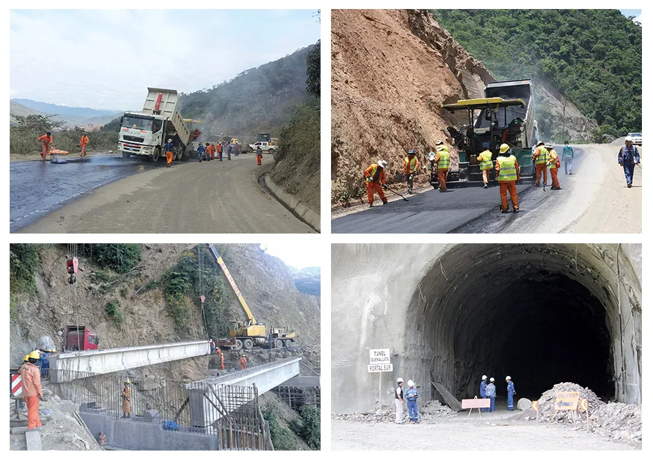
Construction of a new route through Bolivia will help deliver improved transport between Latin America’s Pacific and Atlantic coasts. The construction of the highway between Santa Barbara-Caranavi-Quiquibey has been carried out by the consortium ARBOL. This firm is a partnership between the Argentinean company Grupo Eling and Administradora de Caminos Boliviana (ABC). The stretch of highway is an important section of the inter-oceanic highway that links the Atlantic and Pacific Oceans. It runs from Brazil through Bolivia to Chile and the major work was completed in December 2014.
The new inter-oceanic highway is regarded as a national priority by the Bolivian Government and the route forms an integral part of the national highway plan. This is because it connects the highways of Chile and Brazil, providing an integrated network that links the region from coastline to coastline. This new highway will aid in the transportation and exports of minerals, agricultural commodities and commerce, as well as boosting tourism and inter-departmental trade. The project has a total cost of US$243.8 million and the work has been financed by the Bolivian Government. In all, the inter-oceanic highway project has taken four years and five months to build. And the construction of the inter-oceanic highway corridor employed 2,000 workers and over 800 pieces of heavy machinery along its different stretches.
The highway stretch between Santa Barbara-Caranavi-Quiquibey is 184km in length and is located in the north-east of the Department of La Paz in the Provinces of Nor and Sud Yungas. This section runs between the cities of Coroico, Caranavi and Palos Blancos and the new highway will reduce travel time from 7 hours to 5 hours, allowing maximum speeds of 60km/h along the straight portions and 40km/h on the curves.
The construction of the Santa Barbara-Caranavi-Quiquibey highway presented a double challenge for contractor Asociación Accidental Arbol. The first challenge was the tremendous complexity of building a road through mountainous terrain over a pre-existing track that was less than 4m wide. The second challenge was handling the logistics for managing such a large undertaking, with all its complexity and challenges, in an area with very difficult access. The construction and expansion of Route F N°3 between the towns of Santa Barbara, Caranavi, Alto Beni and Quiquibey is mostly through the Yungas (mountains) of the Department of La Paz up to the border with the Department of Beni. This route unites Northern Brazil with the Pacific Ocean.
From a geological point of view, the city of La Paz is on the edge of the Bolivian Altiplano which is sedimentary basin from the Tertiary-Quaternary Period. This has a substrate formed of a folded stratification, which is visible in the natural areas that surround the city. Towards the north-east come the Cordillera Real and on the other side are the slopes of the Cordillera de Yungas, which is a segment of the main mountain range.
The area close to the city of Caranavi is high in the Cordillera Real, which is made up of very high and medium high mountains with deep valleys between them and very steep precipices. On the eastern slope there is a U-shaped glacial valley with typical geomorphology. The terrain is heavily stratified with shales, sandstones and quartzites interbedded with shales. The predominant mountainous terrain is steep with vertical slopes (60-80°), and subject to strong annual rainfall which causes slope instability, coupled with the diversity of folded and fractured sediments; all these factors create large areas of geological risk.
The area of Nor Yungas has a very diverse geomorphology and is prone in the rainy season to mudslides. The major technical difficulties emerged with slope cuts in mountainous areas where over 100m high cuttings were made by blasting the rock with explosives. There were also additional challenges in moving large volumes of earth and rock (8.2 million m³) and excavating three tunnels and building multiple bridge structures.
The Santa Barbara to Caranavi segment has a length of 59.87km and runs parallel to the Caranavi River. This segment features an area of steep slopes with soil type composed of rock and soil colluvium. Periodic maintenance of this stretch comprises laying gravel, slope stabilisation, and works that contribute to improved road safety such as widening banking and installing safety barriers. The maximum speed for this section is 40-70km/h, while the road is 7m wide with a 0.5m strip on both sides. It features cross slopes of up to 2.5% and its most extreme radius of curvature is 50m. The road surface is made up of a 50mm asphalt surface, lying on top of a bed of crushed material. In all 166 drainage ditches were built in this stretch to handle rainfall and prevent flooding while the contractor built 207 containment walls to prevent landslides.
The second segment of the road between Caranavi and Alto Beni has a total distance of 60.3km and runs over undulating topography with a type of soil consisting of rock and soil colluvium. This area has better characteristics in terms of stability than the previous section. The maximum speed for this section is also 40-70km/h, while the road has the same basic design and construction in terms of width, cross slope, radius of curvature and structure. In all 296 drainage culverts were built in this segment as well as 186 containment walls to prevent landslides.
Segment III between Alto Beni River and Quiquibey has a length of 53.3km and covers a hilly topography over clay soil. This area has better characteristics in terms of stability than the previous section. The maximum speed for this section is 40-70 km/h, the width of the road is 7m with 1m on both sides, a cross slope of 2.5% and a radius of curvature of 50m. The road surface is made up of a 5cm in depth asphalt surface over a bed of crushed material. In all 197 drainage culverts were built in this segment to prevent flooding of the roadway during periods of heavy rainfall although the slopes were more stable and there were only two containment walls needed to prevent landslides.
There are three tunnel stretches along the route, all of which are located in segment I, between Santa Barbara and Caranavi. The Quenallata tunnel is the first of these, with a length of 768m and designed to carry two lanes of traffic. The second tunnel is known as Cajones I and is 364m long, while the third tunnel is known as Cajones II and is 354m in length. All three tunnels have been constructed to a similar design, wide enough for two lanes of traffic with a paved surface 7m wide and 0.7m of shoulder on either side. The tunnels have emergency exits while additional works carried out has involved constructing entry and exit portals, reinforcement, concrete placement, placement of metal anchors, internal drainage and lighting and ventilation.
Meanwhile this highway project also includes the construction of bridges in three sections. One at Kilometer 14 in Segment I at Villa Espada, the second at Kilometer 27 in Abaroa and a third at Kilometer 37 in Segment II at Islas Verdes. n
Information for this article was provided by the Bolivian Highway Commission (ABC).
| Segments | |
|---|---|
| Road Length (km) | |
| Desaguadero – Río Seco | 96km |
| Río Seco – La Paz | 19km |
| Río Seco – La Paz | 48km |
| Cotapata – Santa Bárbara | 49km |
| Santa Bárbara - Quiquibey | 182km |
| Quiquibey – Yucumo | 41km |
| Yucumo – Rurrenabaque | 102km |
| Rurrenabaque – Santa Rosa – Yata - Australia Australia - El Chorro (El Triángulo) - Riberalta | 510km |
| Riberalta – Guayaramerín | 86km |
| Yucumo – San Borja – Trinidad | 282km |
| El Chorro – Porvenir - Cobija | 409km |
| Source: ABC |
| Technical Figures | |
|---|---|
| Rock and earth excavated | 8.2 millon m³ |
| Earth filling | 1.3 millon m³ |
| Concrete | 45,000 m3 |
| Culverts | 9.4km |
| Source: ABC |