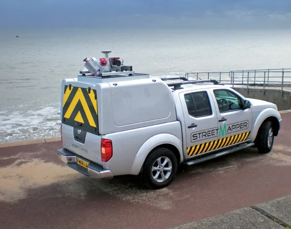
Topcon says that its new IP-S2 package combines GNNS positioning capabilities with inertial sensors, while the firm also has a solution for customers wanting to mix and match receiver components. The IP-S2 is a vehicle-mounted, mobile 3D tool that offers precision mapping and surveying capabilities. The package collects data using 3D laser scanners, LIDAR, and/or cameras, and this is then integrated, time-stamped and geo-referenced. The customer can use this assembled data to combine LIDAR point cloud and d

to build 3D models of the areas that have been scanned.
Topcon's inertial positioning system (IPS) makes it possible to track motion through 3D space, providing a solution to asset management and data collection applications. The package is said to deliver high accuracy scanning and inertial measurement capabilities and can support a variety of sensors, while it also offers a 360º hemispherical digital video camera system. As a result the IP-S2 can gather accurate measurement data in difficult conditions, such
as tunnels, under bridges or urban canyons according to the firm.
The IP-S2 system can be used to improve asset management tasks as it collects data and provides a precise location of any subject, using digital photography capabilities, as well as laser scanning options. Using this package will reduce the time needed for field data collection for GIS applications and will allow for more complete databases, while also boosting safety as there is no longer a need for personnel to stand in busy working areas or roads carrying heavy traffic where many assets are located. A single pass with a vehicle travelling at normal speed can provide a complete dataset of highly accurate position information and high resolution imagery using the system according to Topcon.
Using software tools, GIS operators can identify features, assign attributes and export this data to geospatial applications. This offers a substantial reduction in cost while boosting safety compared to traditional ground survey methods.
The IP-S2 standard system includes three high-resolution LiDAR scanners that cover the vehicle path at ground level and sweep the adjacent areas to 30m. The technology offers location and geo-referencing with survey accuracy of visible utilities, traffic signals and roadways, modeling GIS maps, examining tunnels, taking inventory of and collecting 360º digital images at a rate of 15 frames/second. The IP-S2 software and hardware have been designed and constructed in a modular format so that different sensors can be integrated to existing scanner ports. The unit also works in coordination with an online data post-processing service to provide data sets with the highest possible accuracy.
Meanwhile the firm's Version 3.4 G3 firmware is said to offer improved tracking technology and can upgrade the performance of all Topcon GNSS receiver platforms, including the popular GR-3 and new GRS-1 systems.
According to Topcon this firmware is the first package available that can automatically detect the make of the network receiver, correct the rover unit and apply the required offset to GLONASS system measurements contained in a GNSS network. Different firms have different offsets for the GLONASS satellite signals. But with hardware manufacturers using differing output values for GLONASS measurements, this has made things tricky for customers to combine tools from varying suppliers inside a GNSS network.
Customers have so far had to employ bases and rover units from the same supplier to use the GLONASS signals. Now the Topcon user can enter the make of the base or network manually inside of TopSURV 7.2.3 field software and the system will apply the proper offsets from the broadcast RTCM 1033 message automatically.
This new package allows a customer to use different makes and models of base stations with Topcon rover systems.