Versilis offers Safety Cloud alerts

Versilis has partnered with Haas Alert to offer motorists Safety Cloud, an infrastructure-to-vehicle (I2V) solution that sends notifications of road layout changes and lane closures
September 3, 2021 Read time: 2 mins
Versilis safety gates are now integrated with Haas Alert’s Safety Cloud, a cellular-V2X (C-V2X) solution that sends real-time digital alerts to drivers

Haas Alert’s Safety Cloud, a cellular-V2X (C-V2X) solution, sends real-time digital alerts to drivers and connected cars to aid drivers in making safer, smarter driving decisions. C-V2X uses 3GPP standardised 4G LTE or 5G mobile cellular connectivity to send and receive signals from a vehicle to other vehicles, pedestrians or to fixed objects such as traffic lights in its surroundings.

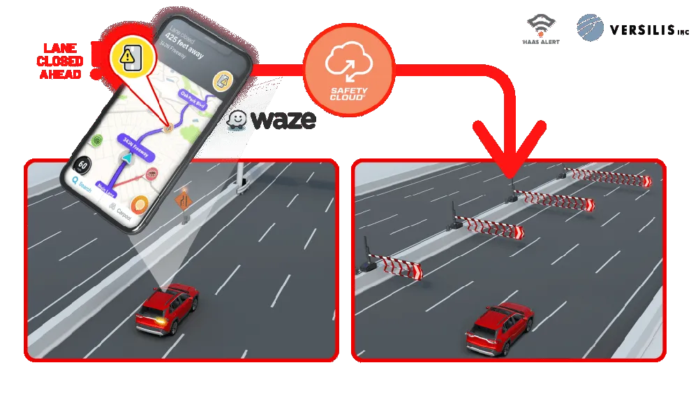
Safety Cloud can now be integrated with Versilis’ access control solutions to provide a real-time automotive collision prevention system improving workers’ and motorists’ safety. Safety Cloud delivers notifications to oncoming motorists that Versilis’ automated signs and gates are in a deployed position, indicating a road or lane closure ahead.

When police, firefighters, EMS crews, tow trucks, and other roadway workers are on-scene or en route to a call, nearby drivers receive real-time alerts through navigation apps and vehicle systems delivered via Safety Cloud.

These alerts are received by motorists, connected cars and autonomous vehicles via in-vehicle systems and navigation applications such as WAZE - a GPS navigation software app and a subsidiary of Google - giving drivers clear advance warning and more time to safely slow down and move over. Receiving an advance warning about the nearby roadway hazard reduces the risk of crashes by up to 90%, according to Haas.

WAZE works on smartphones and tablet computers that have GPS support. It provides turn-by-turn navigation information and user-submitted travel times and route details, while downloading location-dependent information over a mobile telephone network.

For more information on companies in this article

Related Content

  • Heijmans’ bright yellow Dynapacs get the green light at Schiphol
    August 5, 2016
    A damp and foggy morning at Amsterdam’s Schiphol Airport in the Netherlands. Some of the five runways are in normal use, but one of them shows a different kind of activity. At a slow but steady pace, a small army of bright yellow machines is repaving the surface. The project is being carried out by Heijmans, one of the largest road-building contractors in the Netherlands.
  • Advanced GNSS capabilities from Topcon
    May 15, 2019
    Topcon claims that its HiPer VR GNSS receiver is compact, light and benefits from advanced GNSS technology. The firm says that the rugged design is built to withstand harsh construction environments. Using Topcon’s sophisticated GNSS chipset with Universal Tracking Channels technology, the HiPer VR tracks every satellite signal. The compact, rugged design also features an integrated IMU and eCompass. The HiPer VR can be used for static or kinematic GNSS post-processed surveys: as a network RTK rover with
  • VIDEO: Telstra drone LIDAR maps Melbourne’s EastLink Mullum Tunnel
    April 13, 2018
    One of the applications for LIDAR is to make high resolution 3-D maps. Self-driving cars are pre-loaded with a LIDAR map of the trials area in which they are permitted to fully self-drive themselves. The cars also have their own LIDAR scanner which captures a real-time LIDAR view of the vehicle’s surroundings. The fully autonomous driving system within these prototype cars compares the real-time LIDAR view against the pre-loaded LIDAR map to significantly increase the accuracy of their self-positioning
  • A new tolled highway brings change for Austin, Texas
    February 10, 2020
    A new highway section in Austin, Texas marks a major departure for the southern US city