Get highly detailed 3D point road surface data from Topcon’s new RD-M2 scanner

April 11, 2025 Read time: 1 min
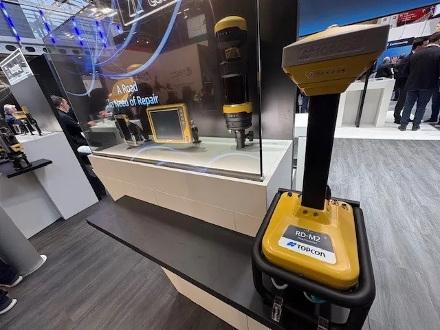
The vehicle-mounted downward-facing RD-M2 from Topcon Positioning Systems delivers precise surface conditions over long and complex roads

Topcon Positioning System’s new RD-M2 laser scanner has been purpose-built for road resurfacing applications.

The vehicle-mounted downward-facing RD-M2 delivers precise surface conditions over long and complex roads, which means no road closures are needed.  

Millions of points are collected by the vehicle operator from safety of his or her cab.

The 3D point data from the RD-M2 scanner serves as the basis for detailed road surface designs using the Topcon Office Suite.  

These ground-truth surfaces are a part of the company’s SmoothRide system workflow.

Users can take advantage of Topcon’s intuitive workflow to create their own custom design from the scan or they can integrate a predefined template.  

Users can also align the scan to the local coordinate system with millimetre-level precision, providing complete flexibility for road resurfacing projects.  

For more information on companies in this article

Related Content

  • Yotta’s Horizons and Mayrise create a route map of the world
    September 14, 2016
    Simon Topp, director of international business at software developer Yotta, explained the need for having the best possible plan in place. Highways agencies and departments the world over face a raft of complex and difficult challenges when it comes to managing and maintaining their infrastructure assets. In some countries, where natural disasters or extreme weather events are endemic, good asset management will need to be supplemented by risk and resilience planning. In the US, for example, the Feder
  • Improved excavators from major firms
    January 31, 2022
    New excavators are being offered that offer improved performance over previous generation machines
  • No strings attached: a Wirtgen SP 15i in Mobile
    May 9, 2019
    A Wirtgen slipform paver SP 15i operated fully automatically to produce kerbs near Mobile, in the US state of Alabama, as the company explains. When a new residential area is developed, the individual contract work sections are often very detailed. Roads and paths have to be paved and access roads to the individual plots constructed. Various traffic areas are often separated by concrete structures such as kerbs. These kerbs can be either pre-cast parts or monolithic profiles produced right on the job sit
  • PTV’s novel traffic analysis system
    April 25, 2013
    German traffic analysis consultant and software maker PTV, which produces the well-known Visum and Vissim strategic traffic analysis and micro-simulation tools, has launched a new assessment tool aimed at studying traffic impact of new developments. PTV Vistro is claimed to be the first all-in­ one-solution for transport analysis and signal optimisation, an easy-to-use software that can be used to conduct traffic studies which are often a mandatory part of development applications and planning approvals.